Jogasaki Coast & Kadowaki Suspension Bridge, Ito: Access, Parking, How to Get There (2026)
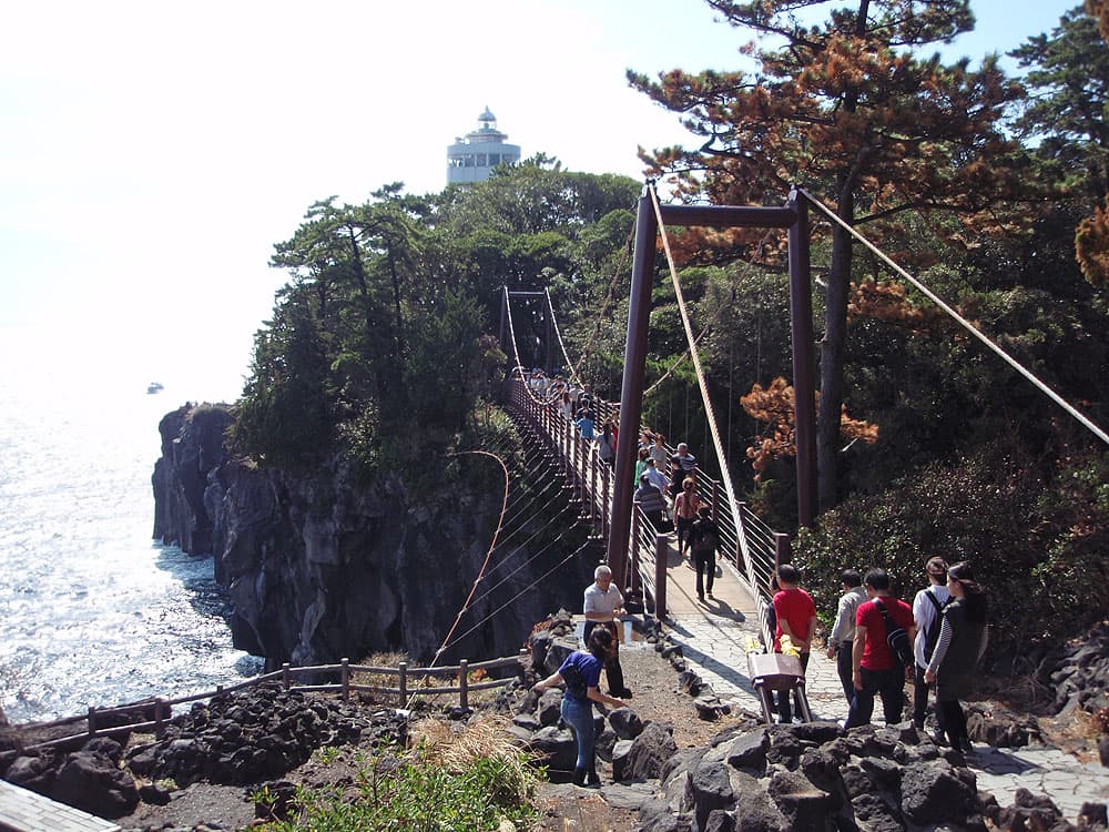
Jogasaki Coast is a cape formed by lava that flowed from Mt. Omuro's eruption about 4,000 years ago. Its landmark, the Kadowaki Suspension Bridge, is 48 m long and about 23 m high, and the seaside Picnical Course trail runs roughly 9 km. To get there: from Izukyu "Jogasaki-Kaigan" Station it is about a 30-minute walk to the bridge (the Ito Tourist Association says about 35 minutes); by car, the nearest lot is the Ito City Kadowaki Parking Lot (123 cars, free for the first 15 minutes, then 500 yen per day). There is no admission fee listed for the coast, the bridge or the Kadowakisaki Lighthouse observation deck (Ito Tourist Association / Izukyu, as of 2026-09-15).
This page covers Jogasaki Coast and the Kadowaki Suspension Bridge in Ito City, Shizuoka: how to get there, parking, how long to allow, the coastal trail, the lighthouse and the seasonal flowers. Every figure comes from the Ito Tourist Association, Izukyu Corporation or Tokai Bus and is dated. For a full day plan that includes Jogasaki, see Ito one-day model course; for getting around without a car, see Ito sightseeing without a car.
The Kadowaki Suspension Bridge (48 m long, 23 m high, as of 2026-09-15)
- A pedestrian suspension bridge on Kadowaki Cape, 48 m long and about 23 m high. Below it, volcanic lava cliffs are cut by the sea and white waves break on the rocks.
- From the bridge you look out over the Izu Islands and the lava-cape landscape. Jogasaki is part of a landform recognized in a UNESCO Global Geopark.
- The Kadowakisaki Lighthouse is just beyond the bridge. No admission fee is listed for the bridge, the lighthouse observation deck or the coastal trail, and no opening hours are stated on the tourist-association or railway pages (it is a natural coastline). There is no lighting at night, so plan to walk in daylight. Opening hours for the lighthouse deck are not stated on the official pages — check the on-site notices (to be confirmed).
How to get there (as of 2026-09-15)
By train (walk from Izukyu "Jogasaki-Kaigan" Station)
- At Ito Station, change to the Izukyu Line (toward Izukyu-Shimoda) and ride about 22 minutes to Jogasaki-Kaigan Station, 650 yen (646 yen with an IC card). From the station it is about a 30-minute walk to the Kadowaki Suspension Bridge (Izukyu; the Ito Tourist Association says about 35 minutes).
- Jogasaki-Kaigan is a log-cabin station. The ticket window is open 9:00–17:00 (closed 12:25–13:25); coin lockers are on the left after the ticket gate. The "Poppo-no-yu" foot bath at the station is closed for the time being.
- There are stairs from the road to the entrance and from the gate to the platform, but slopes are installed on both (Izukyu).
By bus (via Izu Ocean Park)
- From Ito Station bus stop 2, take the "Kaiyo-koen" bus (Tokai Bus I31 / I35), about 42 minutes, and get off at the last stop, "Izu Kaiyo-koen." From there it is about a 20-minute walk to the bridge. From Izu-Kogen Station it is about 9 minutes (Tokai Bus).
- If you will ride the bus several times, the Izu-Kogen & Jogasaki 1-Day Pass (adults 1,250 yen, children 630 yen, same day only) is an option. Note that its free zone is based around Izu-Kogen Station; services to and from Ito Station are outside the zone.
By car
- Set the car navigation to "Ito City Kadowaki Parking Lot." About 2 hours from Atsugi IC (Tomei Expressway), or about 1 hour 30 minutes from Nagaizumi-Numazu IC (Ito Tourist Association).
Parking (Ito City Kadowaki Parking Lot, as of 2026-09-15)
| Item | Detail |
|---|---|
| Name | Ito City Kadowaki Parking Lot (nearest to the bridge and lighthouse) |
| Capacity | 123 cars, 3 micro-buses |
| Fee | Free for the first 15 minutes, then 500 yen per day |
- Fee and capacity are from the Ito Tourist Association (as of 2026-09-15). The lot fills up on holidays and in the hydrangea season, so consider public transport too.
The coastal trail (Picnical Course / Nature Trail, as of 2026-09-15)
- The seaside walk is the Picnical Course (about 9 km) and the Nature Trail. The Kadowaki bridge and lighthouse sit at roughly the midpoint.
- The Ito Tourist Association's hiking course "Boranaya to Kadowaki Bridge" gives these times: Futo fish-watch hut → (3 min) Boranaya → (25 min) end-of-Edo battery ruins → (10 min) Tsubakuro Island viewpoint → (10 min) Kadowaki Suspension Bridge → (1 min) Kadowakisaki Lighthouse.
- Parts of the trail are sometimes closed for resurfacing work; when that happens you detour onto the road (the sidewalk of city road Jogasaki Line). Check the latest tourist-association notice and on-site signs before you go.
- The trail has rocky sections and stairs and is slippery in the rain. Wear proper walking shoes. If rain is forecast, the indoor options in Ito on a rainy day with kids are a safer bet.
The lighthouse, rest area and toilets (as of 2026-09-15)
- The Kadowakisaki Lighthouse has an observation deck with a 360-degree panorama over the Izu Islands and the Amagi mountains.
- Near the lighthouse entrance there is a rest area, toilets and a lighthouse shop selling ice cream and souvenirs (Ito Tourist Association).
- Near the bridge is a spot with a local legend called "Hanshiro-otoshi."
Seasonal highlights and flowers (as of 2026-09-15)
- June: hydrangea; July: Hemerocallis (hama-kanzo) and Star lily (sukashi-yuri); autumn: Chrysanthemum pacificum (iso-giku) and Farfugium (tsuwabuki) — Ito Tourist Association.
- Tsubakuro Island is a breeding ground for the Pacific swift, which arrives from Southeast Asia in late March–early April, nests in May–July and leaves the island around September.
How long to allow
- Just the bridge and lighthouse: about 1.5–2 hours including the round-trip walk from the station.
- Walking the trail as far as Boranaya: allow a little over 2 hours for the whole route. The restaurant Boranaya (Futo 837, Ito; closed Thursdays) changes its hours with the catch, so check its official site on the day you visit.
Combine with Mt. Omuro and Ito's festivals
The eruption that created Jogasaki's lava came from Mt. Omuro, just inland. You can visit Jogasaki (the Kadowaki bridge) and Mt. Omuro on the same day by train and bus — see Ito one-day model course. Ito's festivals and events are collected in the Ito festivals & events calendar 2026-2027.
Sources and update policy
Access, parking, fares and timings were transcribed on 2026-09-15 from the Ito Tourist Association "Jogasaki Coast" and "Volcanic Cape Hike" pages, Izukyu "Jogasaki-Kaigan Station" and fare table, and Tokai Bus. Lighthouse-deck hours and any trail closures are not stated on the official pages or may change, so check on-site notices and the latest official information before you set out.
Preguntas frecuentes
- How long and how high is the Kadowaki Suspension Bridge?
- The Kadowaki Suspension Bridge is 48 m long and about 23 m high. Below it are lava cliffs formed by Mt. Omuro's eruption, and from the bridge you get an ocean view toward the Izu Islands (Ito Tourist Association, as of 2026-09-15).
- How do I get to Jogasaki Coast and the Kadowaki bridge?
- By train, it is about a 30-minute walk from Izukyu “Jogasaki-Kaigan” Station to the bridge (the tourist association says about 35 minutes); from Ito Station the Izukyu ride is about 22 minutes for 650 yen (646 yen by IC card). By bus, take the “Kaiyo-koen” bus from Ito Station stop 2 (about 42 minutes) to the last stop and walk about 20 minutes (Izukyu / Tokai Bus, as of 2026-09-15).
- Is there parking at Jogasaki Coast, and what does it cost?
- The nearest lot is the Ito City Kadowaki Parking Lot: 123 cars and 3 micro-buses, free for the first 15 minutes and then 500 yen per day. It fills up on holidays and in the hydrangea season, so consider public transport (Ito Tourist Association, as of 2026-09-15).
- Is there an admission fee for the bridge or the coast?
- No admission fee is listed for the coastal trail, the Kadowaki Suspension Bridge or the Kadowakisaki Lighthouse observation deck, and no opening hours are stated on the tourist-association or railway pages (it is a natural coastline). Check the on-site notices for the lighthouse-deck hours (as of 2026-09-15).
- How much time should I allow to see the bridge?
- For just the bridge and lighthouse, allow about 1.5–2 hours including the round-trip walk from the station; if you walk the trail as far as Boranaya, allow a little over 2 hours. The route has rocky sections and stairs, so wear proper shoes (as of 2026-09-15).
- Can I visit Jogasaki Coast and Mt. Omuro in one day?
- Yes. Jogasaki (the Kadowaki bridge) and Mt. Omuro can be done on the same day by train and bus; our Ito one-day model course lays out the order and approximate times (as of 2026-09-15).
- Is it accessible by stroller or wheelchair?
- Jogasaki-Kaigan Station has slopes from the road to the entrance and from the gate to the platform, but the coastal trail has many rocky sections and stairs and is not suited to strollers or wheelchairs. Check the Izukyu station accessibility information for details (to be confirmed, as of 2026-09-15).